

The multi beam sounding system, also known as the multi beam echo sounder, bathymeter or multi beam bathymetry sonar, The objective in order to improve the efficiency of Seabed terrain measurement . The traditional Single beam sounding system can only obtain a submarine depth value under the measurement ship vertical beneath in each measurement, Compared with it, Multi beam detection system can obtain Multi beam detection system can obtain a strip cover multiple measurement points within the region of seafloor depth value, To achieve a leap of "point –line measurement"to”line- surface measurement”. The technical progress meaning very prominent.
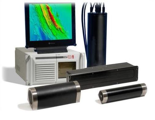
The multi beam sounding system is a complex system for multi sensor, it is a highly integrated Modern signal processing technology, high performance computer technology, high resolution display technology, high precision navigation and positioning technology, digital sensor technology and other related technology. It is possible to obtain multiple simultaneous (typically 127,256) adjacentnarrow beam echo sounding system. Multi beam sounding system in general by the narrow beam echo sounding equipment (transducer, The sensing device of measurement ship swaying,transceiver etc.) and echo processing equipment (computer, digital tape recorder, digital printers, lateral depth profile display, real-time contour digitalplotter, system control keyboard) two parts.
Compared with the single beam echo sounder, The multi beam sounding system has the advantages of large measurement range, high measurement speed, accuracy and high efficiency. The sounding technique is extended from point, line to surface, And to the further development of the stereo sounding and automatic mapping, Particularly suitable for large area Seabed terrain detection.
Component
The typical multi beam system includes 3 subsystems:
1, Multi beam acoustic subsystem includes multi beam transmitting and receiving transducer Array
(sonar probe) and processing of electroniccontrol system of multi beam signal.
2, Auxiliary equipment: differential DGPS satellitepositioning system Providing geodetic coordinate, attitude sensor providing surveying ship rolling, pitching, yaw, heave and attitude data, Tide gauge, Sound velocity profiler.
3,Data processing software (for example, Hypack) and the related softwareand data display, output,
storage equipment).
The main field of application:
Offshore oil and gas installation, hydrological survey, dredging, cable laying,marine monitoring, marine research and environmental monitoring business.
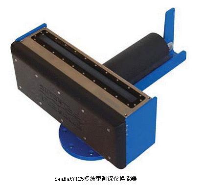
Technical parameters (7125 SV2):
Power supply: 111/220 VAC, 50/60 Hz average 500W
System of limit depth: 25m (with underwater robot can reach 6000m)
Working depth: 0-500m
Frequency: 200kHz or 400kHz (dual frequency combination probe, frequency conversion)
Transmitting beam width: 1 ° (± 0.2 °) in 400kHz, 2.2 ° (± 0.5 °) in 200kHz
The receiving beam width: 0.54 ° (± 0.03 °) at 400kHz, 1.1 ° (± 0.05 °) in 200kHz
The maximum rate of Ping: 50Hz (+ 1Hz)
Pulse length: 33 μ sec to 300 μ sec
Wave: can transmit 512 channel beam simultaneously
The maximum emission angle: 165 °
The depth resolution: 6mm
Storage temperature: - 30 ℃ to +55 C
