

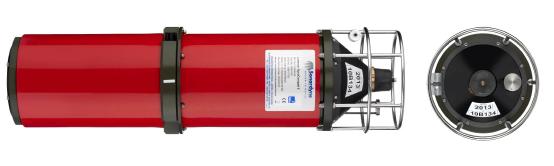
Lodestar GyroCompatt 6 integrates Sonardyne’s Wideband 2 acousticpositioning and Lodestar AHRStechnology in one small, highly versatile and robust instrument. This provides high update rate wirelessattitude, heading, heave, surge,sway, pressure, SV and acoustic positioning of any subsea object.Compatible with USBL and LBLpositioning systems, the Lodestar GyroCompatt 6 provides real time motion data for structure deployment via the integrated high speed acoustic modem.
The internal high capacity rechargeable battery pack enables quick charge times and up to 20
The instrument is small and light enough to be ROV installed and a mechanical stab enables precision alignment to any structure.
Structure position and orientation can be accurately determined during lowering, set-down and as-built surveys. Using the Lodestar GyroCompatt 6 for metrology delivers the measurements required for pipe-end coupling.
The stab, gyro and transducer are pre-aligned and this speeds up spot measurements as only single observations are required.
Autonomous logging negates the need for a vessel and ROV to be on standby taking measurement during long term settlement observations.
Feature
Depth rating 3,000 Metres
Operating Temperature -5°C to +40°C
External Battery Pack / ROV Supply 24V (18 – 50V)
Battery Life Acoustic Navigation Standby 2 Months
Lodestar Permanently Powered On 20 Hours
Acoustic Compatt 6 Operating Frequency MF (19-36kHz) Sonardyne WidebandR 2
Transmit Source Level 185-192dB re 1μPa @ 1m (5 Levels)
Ranging Precision Better than 15mm
Telemetry Protocol Sonardyne SMS and Modem
Ranges Tracked 14 Simultaneous Replies
Lodestar AHRS Heading Range 0-360°
Accuracy 0.1° Secant Latitude RMS
Settle Time <5 Minutes
Follow Up Speed 500°/ Second
Resolution 0.01°
Roll and Pitch Range ±180o (No physical limit)
Accuracy 0.01°
Resolution 0.01°
Heave Range ±99m
Accuracy (Real Time) 5cm or 5% (Whichever is the greater)
Bandwidth User selectable
Resolution 0.01m
